| WPC Met Watch |
|
|
Mesoscale Precipitation Discussion: #0300 |
|
(Issued at 225 AM EDT Wed May 21 2025
) |
|
| MPD Selection |
|
|
|
|
|

Mesoscale Precipitation Discussion 0300
NWS Weather Prediction Center College Park MD
225 AM EDT Wed May 21 2025

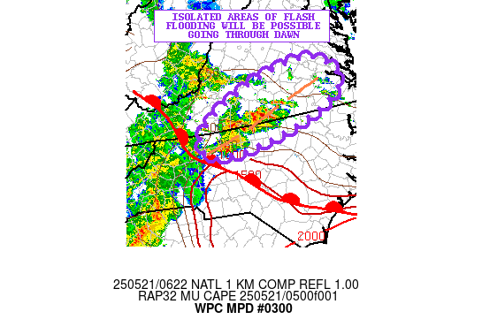
Areas affected...North-Central NC into South-Central VA

Concerning...Heavy rainfall...Flash flooding possible

Valid 210625Z - 211130Z

SUMMARY...Locally slow-moving and repeating areas of showers and
thunderstorms will be impacting portions of north-central NC and
into south-central VA going through dawn. Isolated areas of flash
flooding will be a concern as a result.

DISCUSSION...Increasing warm-air advection and moisture transport
riding up across the southern Mid-Atlantic region along with the
arrival of a warm front will help to focus a gradual increase in
shower and thunderstorm activity across north-central NC and
especially south-central VA over the next few hours going into the
dawn time frame.

The latest surface analysis shows a front draped northwest to
southeast across western and central NC and there is a pooling of
elevated instability noted poleward of this boundary with MUCAPE
values as high as 500 to 1000 J/kg nosing up through northern NC.
A southwest low-level jet should becoming a bit better defined
over the next few hours, and increasing to as much as 30 to 35+
kts by 09Z (5AM EDT) across the region based on the latest RAP
forecast.

This will result in increasing isentropic ascent and a further
expansion of elevated instability up into south-central VA.
Meanwhile, the arrival of mid-level troughing/energy from upstream
over the OH/TN Valley region is expected to be interacting with
the front and should foster a developing wave of low pressure
along as it lifts gradually northward very early this morning.
This will yield a corridor of strong low-level convergence/forcing
near the front which will favor additional concerns for areas of
elevated convection to develop and become a bit more concentrated.

The 00Z HREF guidance suggests the potential for rainfall rates
with some of the elevated convection to reach as high as 1.5
inches/hour. There may be some repeating cell-activity in a
southwest to northeast fashion near an inverted surface trough
north of the front, and that could support some totals by dawn of
as much as 2 to 3+ inches. As a result, there may be some isolated
concerns for flash flooding given more enhanced runoff potential.

Orrison

ATTN...WFO...AKQ...RAH...RNK...

ATTN...RFC...ALR...RHA...NWC...

LAT...LON   37607716 36947679 36277833 36028016 36468049
            37017980 37547839
Download in GIS format: Shapefile
| KML
Last Updated: 225 AM EDT Wed May 21 2025
|


