| WPC Met Watch |
|
|
Mesoscale Precipitation Discussion: #0299 |
|
(Issued at 108 AM EDT Wed May 21 2025
) |
|
| MPD Selection |
|
|
|
|
|

Mesoscale Precipitation Discussion 0299
NWS Weather Prediction Center College Park MD
108 AM EDT Wed May 21 2025

Areas affected...Portions of Northern GA including the Atlanta
Metropolitan area

Concerning...Heavy rainfall...Flash flooding possible

Valid 210508Z - 210730Z

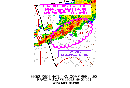
SUMMARY...A band of heavy showers and thunderstorms will continue
to settle gradually southeastward across areas of northern GA.
These heavy rains will impact the broader Atlanta metropolitan
area within the next 1 to 2 hours and may cause some urban flash
flooding.

DISCUSSION...The latest radar imagery shows a long-lived band of
showers and thunderstorms approaching the Atlanta metropolitan
area with heavy rainfall rates of 1 to 2 inches/hour. The
convection continues to be maintained by the pooling of moisture
and instability ahead of it.

In fact, a southwest low-level jet of 30 to 40 kts is noted with
as much as 500 to 1000 J/kg of MUCAPE. This coupled with some
elevated effective bulk shear values (50+ kts) is still helping to
foster some strong organized updrafts and will likely still favor
some convective sustenance over the next couple of hours despite
the battle with increasing boundary layer CINH/nocturnal cooling.

Generally the shower and thunderstorm activity is rather
progressive, but there may be sufficient levels of brief
cell-training to yield some rainfall totals as high as 2 to 2.5
inches before the band of convection exits the region off to the
south and east and weakens.

Given the urban environment that these rains will be falling over
within the next 1 to 2 hours, there may be some runoff concerns
and potential for at least localized flash flooding.

Orrison

ATTN...WFO...FFC...

ATTN...RFC...ALR...NWC...

LAT...LON   34248417 34218355 33818350 33498425 33488499
            33798516 34088476
Download in GIS format: Shapefile
| KML
Last Updated: 108 AM EDT Wed May 21 2025
|


