| WPC Met Watch |
|
|
Mesoscale Precipitation Discussion: #0297 |
|
(Issued at 530 PM EDT Tue May 20 2025
) |
|
| MPD Selection |
|
|
|
|
|

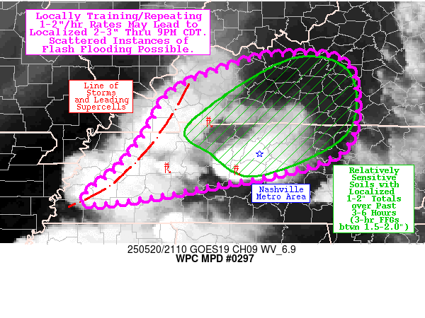
Mesoscale Precipitation Discussion 0297
NWS Weather Prediction Center College Park MD
530 PM EDT Tue May 20 2025

Areas affected...portions of central and northern West/Middle TN
into western and central KY

Concerning...Heavy rainfall...Flash flooding possible

Valid 202130Z - 210200Z

Summary...Training and repeating of 1-2"/hr rates may lead to
localized totals of 2-3" (much of which will occur over relatively
saturated soils) through 9PM CDT. Scattered instances of flash
flooding are possible.

Discussion...Semi-discrete severe thunderstorms are rapidly
organizing linearly near (and just east) of the MS River (along
the TN/AR/MO/KY border). This is occurring within a deeply
unstable (2000-3500 J/kg of SBCAPE) warm sector, with the clearing
cold front lagging significantly behind the line of storms (across
eastern AR/southwest MO). Precipitable water along and ahead of
the storms is between 1.5-1.9 inches, between the 90th percentile
and record levels for the Nashville area (per BNA sounding
climatology), and moderate to strong low-level moisture transport
will transport these highly anomalous values northeast into the
MPD region (with 925-850 mb flow of 35-45 kts). A semi-phased jet
stream is providing sufficient diffluence aloft (though not ideal,
within the right exit region of the broad jet streak), and ample
deep layer (0-6 km) shear (50-60 kts) to organize updrafts into
supercell structures (which are occurring both along and out ahead
of the main line).

The primary concern going forward with regard to flash flooding
are for continued proliferation of convection to result in
training and repeating elements along and out ahead of the main
line. Notably, Flash Flood Guidance (FFG) across northern Middle
TN into south-central KY is much lower than surrounding areas
(1.5-2.0" over 3-hr), and this may contribute higher coverage (and
greater potential for locally significant) flash flooding. MRMS
QPE CREST unit streamflow indicates somewhat elevated activity in
this region already, as NSSL QPE estimates 1.0-2.0" totals over
the past 6 hours from an earlier line of storms.

Hi-res guidance is in relatively good agreement with QPF through
02z (9pm CDT), depicting localized 2-3" totals over the next 3-5
hours (per 18z HREF and experimental 12z RRFSe PMM QPF, as well as
the 90th percentile accumulated rainfall of the 19z and 20z runs
of the experimental WoFS). Given the aforementioned wet antecedent
conditions, this suggests 20-40% chances for FFG exceedance (per
40-km neighborhood method of the 18z HREF and 12z RRFSe
ensembles). Scattered instances of flash flooding are possible.

Churchill

ATTN...WFO...LMK...MEG...OHX...PAH...

ATTN...RFC...ORN...TIR...NWC...

LAT...LON   37778649 37698540 37138513 36348524 36038574
            35758687 35338956 35958899 36528856 37148819
            37488745
Download in GIS format: Shapefile
| KML
Last Updated: 530 PM EDT Tue May 20 2025
|


