| WPC Met Watch |
|
|
Mesoscale Precipitation Discussion: #0116 |
|
(Issued at 128 AM EDT Fri Apr 04 2025
) |
|
| MPD Selection |
|
|
|
|
|

Mesoscale Precipitation Discussion 0116...Corrected
NWS Weather Prediction Center College Park MD
128 AM EDT Fri Apr 04 2025

Corrected for DISCUSSION ERROR

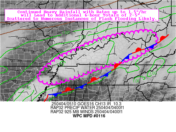
Areas affected...Mid-South to the OH/TN Valleys

Concerning...Heavy rainfall...Flash flooding likely

Valid 040515Z - 041115Z

Summary...Continued heavy rainfall with rates up to 1.5"/hr will
lead to additional 6-hour totals of 2-5". Scattered to numerous
instances of flash flooding are likely.

Discussion...Clusters of convection continue to slowly backbuild
across portions of the Lower MS Valley, mainly over the Ozarks and
Delta of AR, arcing northeastward into the OH/TN Valleys with the
deep layer flow. A broad low-level jet (35-55 kts at 850 mb) is
providing seemingly unending strong moisture transport into a
narrow, clearly defined axis of overrunning/frontogenesis (also
ideally in the right-entrance region of a 140+ kt jet streak over
southeastern Canada). The mesoscale environment is characterized
by MU CAPE of 250-1000 J/kg, precipitable water values of 1.3-1.6
inches (near the max moving average, per BNA sounding
climatology), and deep layer (0-6 km) shear of 60-80 kts.

Northeasterly-directed deep layer flow will support a relatively
narrow axis of repeating heavy rainfall over the next 6 hours,
with a consensus of hi-res CAMs (00z HREF suite) suggesting
additional localized totals of 2-4" (with rates generally capped
at 1.5"/hr due to instability being somewhat limited). This heavy
rainfall is expected to occur over areas that have already seen as
much as 3-7" of rainfall over the past 24 hours (per NSSL
estimates). Given all of the recent heavy rainfall, it will not
take much additional rainfall to cause continued or renewed
flooding, as Flash Flood Guidance (FFG) is indicated to be 1.0" or
less for the bulk of the region. With hi-res models (00z HREF)
indicating relatively high odds for localized 2" exceedance (40-km
neighborhood probabilities of 20-50%), scattered to numerous
instances of flash flooding are considered likely. Should these
2-5" streaks of rainfall occur over particularly sensitive
terrain, flooding may be locally significant.

Churchill

ATTN...WFO...ILN...JKL...LMK...LZK...MEG...OHX...PAH...RLX...

ATTN...RFC...LMRFC...OHRFC...NWC...

LAT...LON   39248266 39138199 38748173 38188196 37928239
            37428322 36898454 36678539 36368647 35848783
            35308941 35209041 35709107 36908981 37788809
            38428664 38758553 38998447 39118361
Download in GIS format: Shapefile
| KML
Last Updated: 128 AM EDT Fri Apr 04 2025
|


