| WPC Met Watch |
|
|
Mesoscale Precipitation Discussion: #0110 |
|
(Issued at 749 AM EDT Thu Apr 03 2025
) |
|
| MPD Selection |
|
|
|
|
|

Mesoscale Precipitation Discussion 0110
NWS Weather Prediction Center College Park MD
749 AM EDT Thu Apr 03 2025

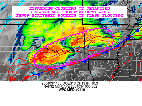
Areas affected...Northern TX...Southeast OK...Western/Central AR

Concerning...Heavy rainfall...Flash flooding likely

Valid 031148Z - 031748Z

SUMMARY...Expanding clusters of heavy showers and thunderstorms
wil tend to further organize this morning and should favor at
least some scattered areas of flash flooding, including an urban
flash flood concern.

DISCUSSION...A deep layer trough over the Four Corners region
continues to channel a strong upper-level jet along with embedded
vort energy out across the southern Plains and toward the broader
lower MS Valley region. This energy is interacting this morning
with a moist and unstable southerly low-level jet of 30 to 40+ kts
across areas of northern TX and southeast OK which is yielding
several clusters of organized and very cold-topped convective
clusters.

A substantial amount of the convection is elevated in nature to
the north of a quasi-stationary front, and generally rooted within
a corridor of MUCAPE values of 1000 to 2000 J/kg. However, notably
higher instability parameters are seen farther south and east into
the warm sector south of the front. This instability coupled with
the moist low-level jet and strong vertical shear is promoting
high rainfall rates and especially with several severe-mode
supercell structures that are evolving across northern TX to the
west of the Dallas-Fort Worth metropolitan area and also locally
across southeast OK.

Strong upper-level jet energy crossing the southern Plains over
the next several hours will provide an expansive area of deeper
layer ascent and shear that will combine with the favorable
thermodynamic environment for sustinable and well-organized
convective clusters. Heavy rainfall is expected locally, and the
rainfall rates are expected to reach 1.5 to 2.5 inches/hour with
the stronger cells.

Some occasional cell-merger activity and localized cell-training
will be possible, and rainfall totals going through midday may
reach an additional 3 to 4+ inches. These rains will be falling
locally on some areas that saw heavy rain yesterday including
parts of northeast TX, southeast OK and western/central AR.
Therefore, with relatively moist antecedent conditions in place
here and additional rains likely to arrive this morning, some
scattered areas of flash flooding are generally likely. Adjacent
areas of northern TX are a bit more conditionl with the flash
flood threat, but there will be concern for urban flooding impacts
should these stronger storms impact some of the larger
metropolitan areas.

Orrison

ATTN...WFO...FWD...LZK...OUN...SHV...SJT...TSA...

ATTN...RFC...ABRFC...LMRFC...WGRFC...NWC...

LAT...LON   35929347 35839213 34859170 34129250 33339421
            32719611 32439748 32389891 33269930 34209824
            35129607
Download in GIS format: Shapefile
| KML
Last Updated: 749 AM EDT Thu Apr 03 2025
|


