| WPC Met Watch |
|
|
Mesoscale Precipitation Discussion: #0109 |
|
(Issued at 706 AM EDT Thu Apr 03 2025
) |
|
| MPD Selection |
|
|
|
|
|

Mesoscale Precipitation Discussion 0109
NWS Weather Prediction Center College Park MD
706 AM EDT Thu Apr 03 2025

Areas affected...Mid-South

Concerning...Heavy rainfall...Flash flooding likely

Valid 031105Z - 031705Z

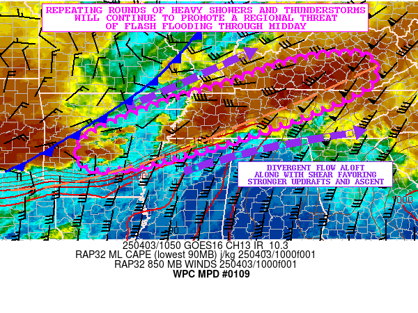
SUMMARY...Additional repeating rounds of heavy showers and
thunderstorms going through midday will continue to favor a
regional threat of flash flooding across the Mid-South.

DISCUSSION...Early morning GOES-E IR satellite imagery shows an
axis of heavy showers and thunderstorms tending to repeat/train
over the same locations across portions of the Mid-South as a
moist and unstable airmass continues to lift north from the Gulf
Coast region.

A moderately buoyant airmass is noted in particular from southeast
AR through northern MS and into a small portion of middle TN with
MLCAPE values of 1000 to 2000 J/kg. Areas off to the northeast
here going up into southeast KY are more stable by comparison with
CAPE values generally under 1000 J/kg. Area VWP data though shows
an impressive southerly low-level jet reaching on the order of 40
to 50+ kts and this is yielding sustainably strong moisture
transport.

The combination of this moisture and instability in conjunction
with a well-defined convectively enhanced surface boundary and
divergent flow aloft should favor sustainable clusters of
convection this morning which will tend to be aligned with the
deeper layer mean flow and thus will promote convective cells
repeating/training over the same area.

The thermodynamic environment will promote rainfall rates with the
stronger convective cores reaching 1 to 2 inches/hour and
especially considering the level of shear (effective bulk shear of
50+ kts) which will favor pockets of strong and organized
updrafts. The PWs are generally on the order of 1.5 to 1.6 and
this will support these high rainfall rates as well and especially
with the strength of the low-level jet.

Additional rainfall totals going through midday should reach on
the order of 2 to 4 inches with isolated heavier amounts possible.
The heaviest of these rains this morning should tend to be over
central and eastern AR through northwest MS and the western half
of TN where there is better pooling of instability. Flash flooding
is already occurring over many of these areas, and additional
flash flooding is expected through midday.

Orrison

ATTN...WFO...HUN...JKL...LMK...LZK...MEG...MRX...OHX...PAH...

ATTN...RFC...ABRFC...LMRFC...OHRFC...NWC...

LAT...LON   37758373 36908347 35968525 35448668 34688896
            34119130 34059300 35039302 36139050 36798830
            37608587
Download in GIS format: Shapefile
| KML
Last Updated: 706 AM EDT Thu Apr 03 2025
|


