|
|
 |
 |
||
 |
| Site Map | News | Organization |
| DOC | NOAA | NWS | NCEP Centers: | AWC | CPC | EMC | NCO | NHC | OPC | SPC | SWPC | WPC |
|
|
|
|
|
||
|
| Site Map | News | Organization |
| DOC | NOAA | NWS | NCEP Centers: | AWC | CPC | EMC | NCO | NHC | OPC | SPC | SWPC | WPC |
|
WPC Medium Range Archive
Medium Range Products Valid On:
05/20/2025
(Day 7 PMDEPD: Valid 05/16/2025 to 05/20/2025)
Extended Forecast Discussion
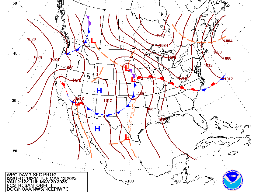
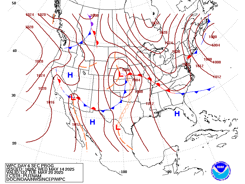
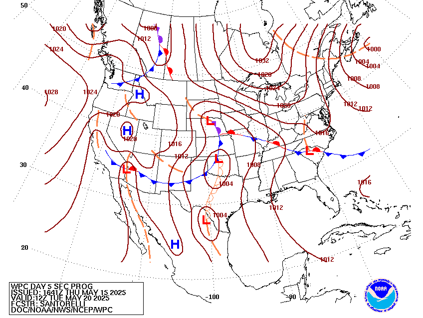
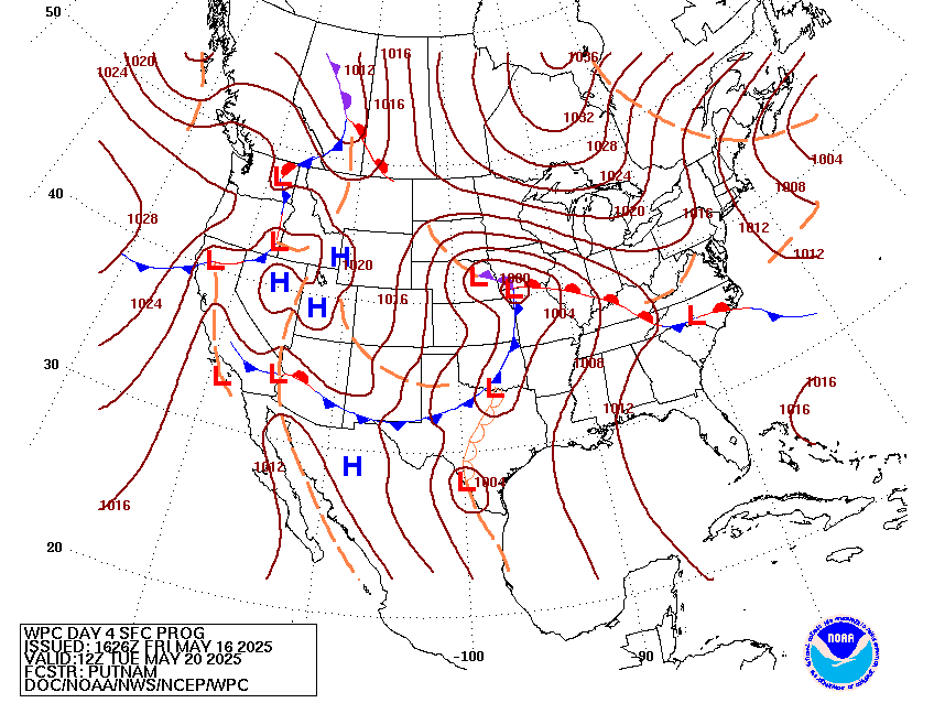
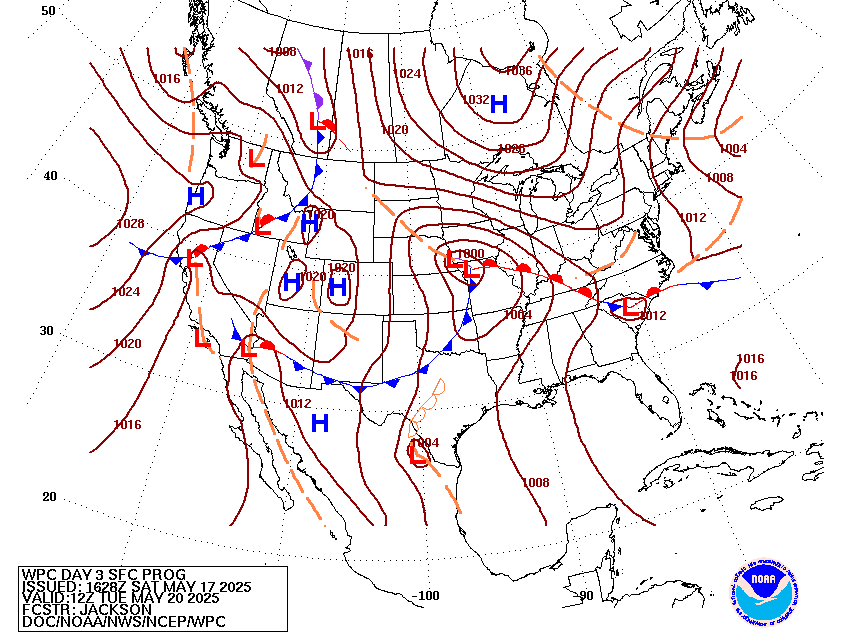
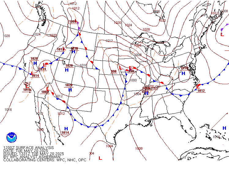
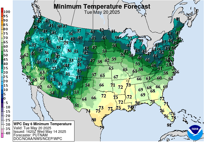
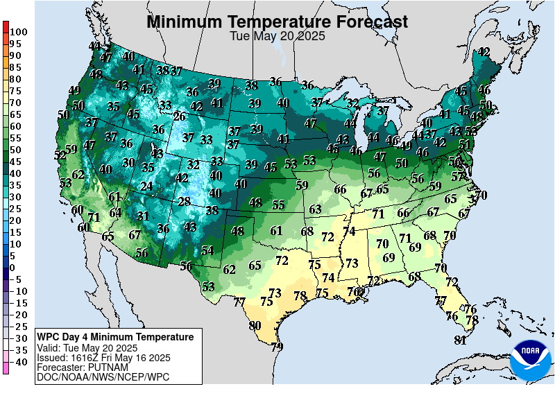
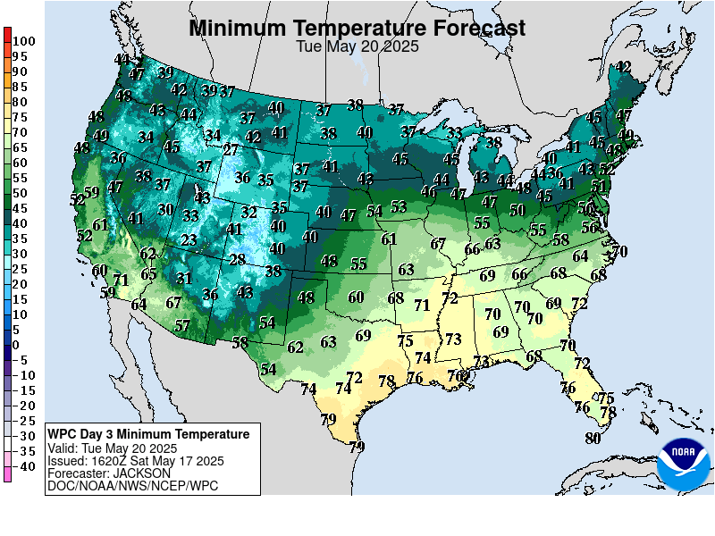
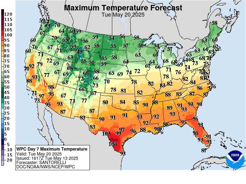
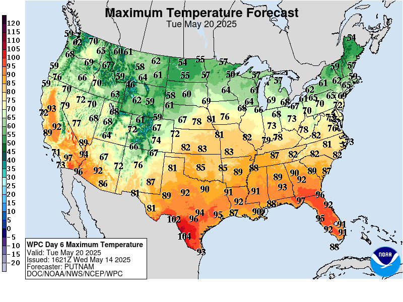
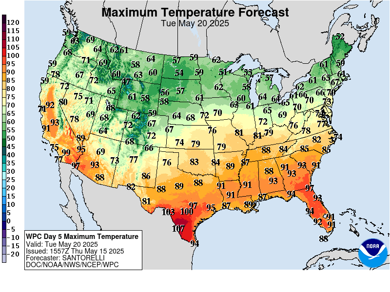
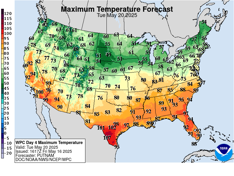
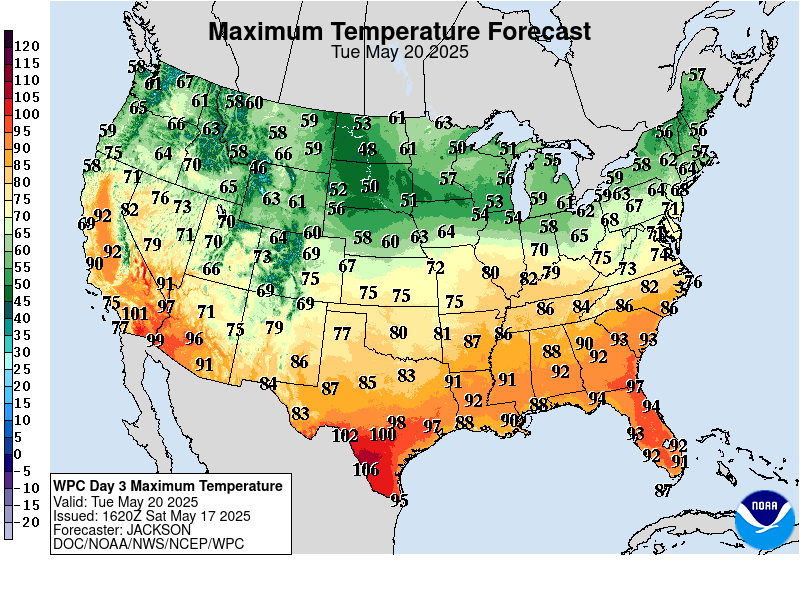
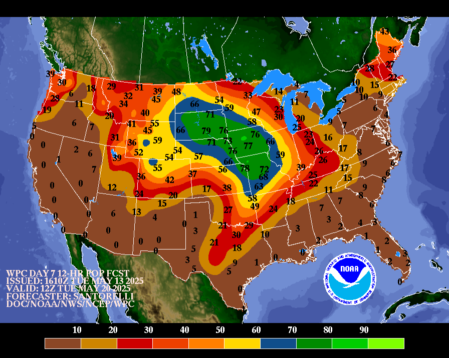
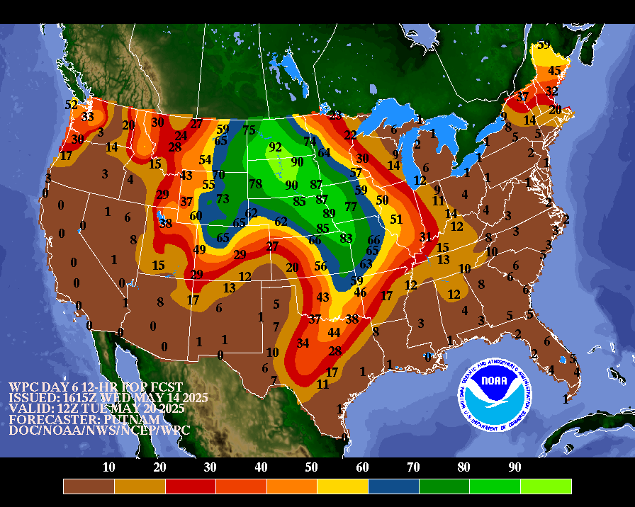
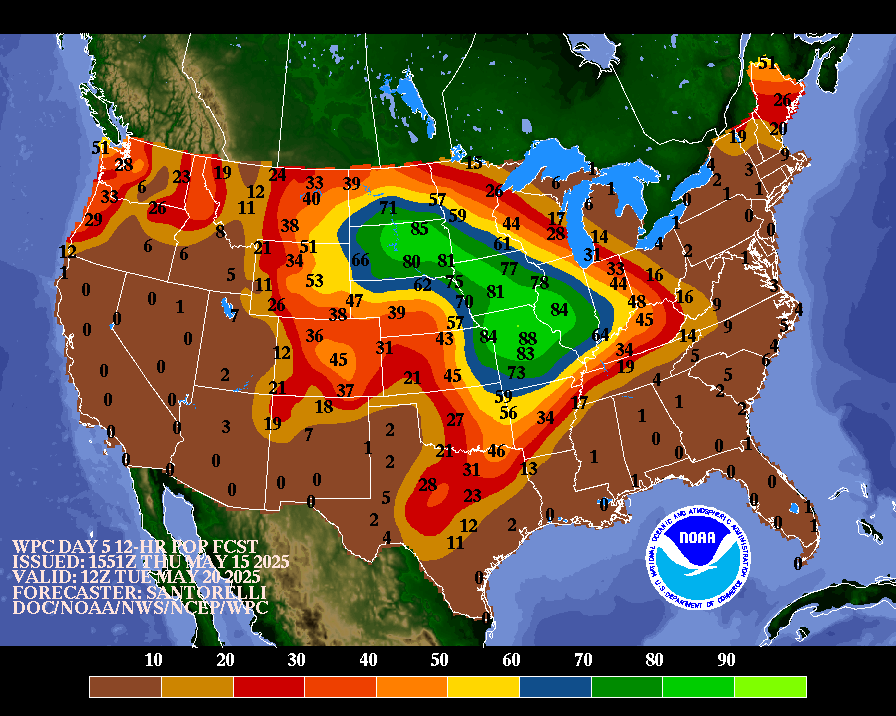
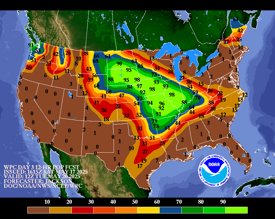
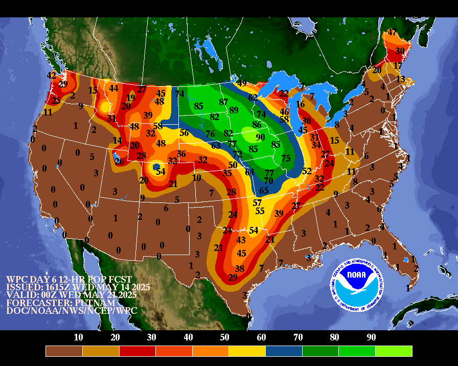
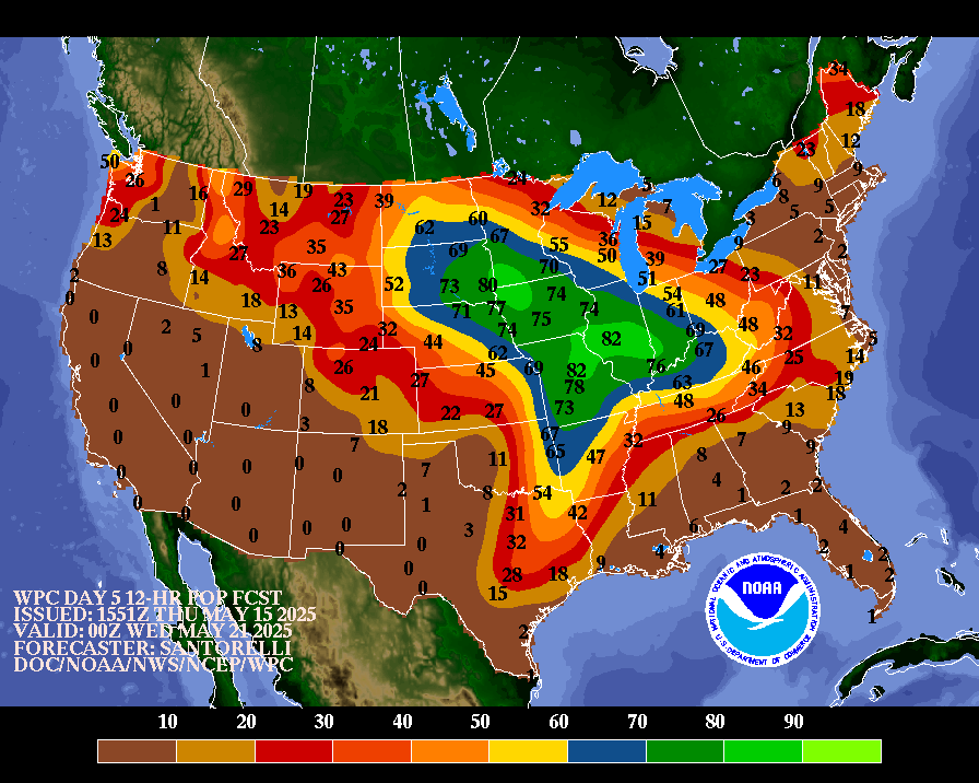
NWS Weather Prediction Center College Park MD 235 PM EDT Tue May 13 2025 Valid 12Z Fri May 16 2025 - 12Z Tue May 20 2025 ...Heat builds across the southern Plains while late season snow is expected for the Rockies... ...General Overview... The strong low pressure system over the northern Plains on Thursday is forecast to lift northeast across Ontario going into Friday, with a strong trailing cold front draping through the Mid- South. Numerous showers and storms are likely along and ahead of the front from the Mid- South to the Ohio Valley and Great Lakes. Attention then turns to the Intermountain West by the weekend as another amplified upper trough and closed low develops and brings additional rounds of valley rain and mountain snow along with cold conditions for this time of year. Early season heat will continue to make weather headlines for the south- central U.S. with an upper ridge axis governing the overall weather pattern. ...Guidance/Predictability Assessment... The 12z model guidance suite today continues to offer very good synoptic scale agreement for the end of the week, with a multi- deterministic model blend sufficing as a starting point in the forecast process and slightly more weighting applied to the ECMWF/GFS solutions. The UKMET remains a bit north of the better consensus with the Great Lakes low and then later in the period there are some differences with how this energy may or may not combine with another shortwave to the north, or the evolution of this off the Northeast coast. Guidance agrees well with another trough amplifying over the West this weekend, with an eventual closed low located over/near the central Great Basin. This low will eventually lift northward into the north-central U.S. early next week but with plenty of uncertainty in energy dispersion within and around low which would have implications on sensible weather across this region. The WPC forecast trended towards the ensemble means late period which showed better consistency and smoothed out the smaller scale differences. ...Weather/Hazards Highlights... Showers and thunderstorms increase in coverage and intensity across the Mid-South and Ohio Valley ahead of a cold front that will be intercepting deeper return moisture. An broad ERO Marginal Risk area remains valid for Friday (Day 4) from Arkansas to the central Appalachians, including portions of the Ohio Valley. Going into Saturday (Day 5) attention then turns to portions of the southern Plains and extending to the Mid-South with enhanced moisture convergence near the same frontal boundary and ahead of a developing wave of low pressure near the Texas Panhandle. Anomalous moisture combined with low flash flood guidance values across parts of the Northeast allowed for the introduction of a marginal risk area on the Day 5/Saturday ERO for this region ahead of a departing front and redevelopment of low pressure offshore. Elsewhere across the nation, the Storm Prediction Center is monitoring the potential for severe weather from the Midwest to the Mid-South to close out the work week with favorable instability and kinematics. Across the Rockies, expect additional chances for late season snow for the central and northern Rockies by Sunday into Monday as the next upper trough and shortwave moves in, with the potential for over a foot of accumulation for some of the highest mountain ranges. At least locally heavy rainfall seems likely to develop across the Great Basin over the weekend and into the north-central U.S. early next week in response to the developing upper low which will continue to be monitored. Very warm weather will be commonplace across the eastern half of the country to close out the work week, with highs well into the 80s and even some lower-middle 90s from the Ohio Valley and Mid- Atlantic southward to the Gulf Coast. Early season excessive heat is expected across southern Texas through the upcoming weekend with highs exceeding 100 degrees near the Rio Grande and into much of central Texas, and HeatRisk reaching the major to extreme category for some of these areas, with temperatures in the 70s providing little to no relief overnight. In contrast, chilly conditions are likely for the Intermountain West and Northern Rockies/Plains with highs running 10 to perhaps 20 degrees below average with the upper level trough and increased cloud cover. Santorelli/Hamrick Additional 3-7 Day Hazard information can be found on the WPC medium range hazards outlook chart at: https://www.wpc.ncep.noaa.gov/threats/threats.php WPC medium range 500mb heights, surface systems, weather grids, quantitative precipitation forecast (QPF), excessive rainfall outlook (ERO), winter weather outlook (WWO) probabilities, heat indices, and Key Messages can be accessed from: https://www.wpc.ncep.noaa.gov/medr/5dayfcst500_wbg.gif https://www.wpc.ncep.noaa.gov/medr/5dayfcst_wbg_conus.gif https://www.wpc.ncep.noaa.gov/5km_grids/5km_gridsbody.html https://www.wpc.ncep.noaa.gov/qpf/day4-7.shtml https://www.wpc.ncep.noaa.gov/#page=ero https://www.wpc.ncep.noaa.gov/wwd/pwpf_d47/pwpf_medr.php?day=4 https://www.wpc.ncep.noaa.gov/heat_index.shtml https://www.wpc.ncep.noaa.gov/#page=ovw
|
||||||||||||||||||||||||||||||||||||||||||||||||


